


%20052026%20SOURCE%20Tello.jpg)


Heartland braces for renewed threat of more tornadoes, damaging hail and wind just days after fatal storms
Severe weather season is wasting no time as another round of severe storms targets the Heartland by midweek, bringing renewed chances for strong winds, damaging hail and possible tornadoes.
This will come just on the heels of a deadly, multi-day severe weather outbreak that ripped through Texas, the Plains, and the Midwest before it charged towards Great Lakes and the Northeast.
Portions of those areas will see another chance for severe storms on Tuesday through Wednesday, with a level 2 out of 5 threat already issued.
The deadly storm system spanned more than 1,500 miles—from Northeast to Texas—and impacted over 90 million people.
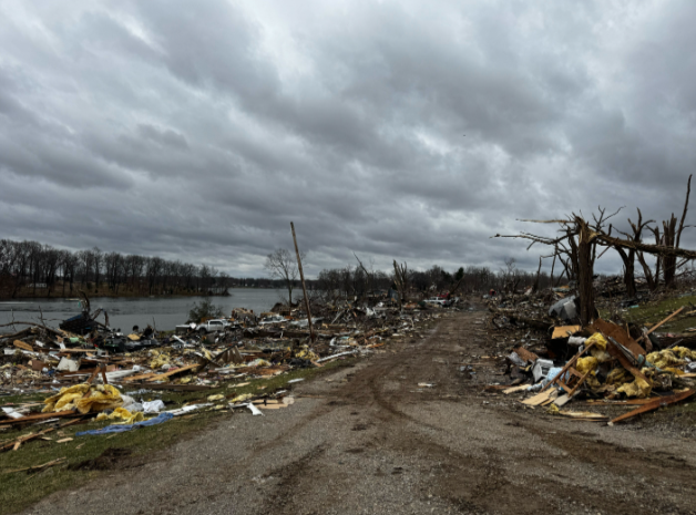
At least nine tornadoes ripped through the Heartland between Thursday and Saturday, ranging in strength from EF-0 to EF-3, claiming the lives of eight people and leaving communities devastated in their wake.
Into early next week, a significant dip in the jet stream is expected to track out of the Rockies and into the Central Plains.
RELATIVE DETAILS THE MOMENTS MOTHER AND DAUGHTER WERE TRAGICALLY KILLED IN OKLAHOMA TORNADO
This system will be accompanied by a mid-level jet moving northeast, while abundant Gulf moisture surges northward to fuel increasing instability and storm development.
On Tuesday, a Level 2 out of 5 severe storm risk is in place from portions of the southern and central Plains eastward into the Ozarks.
MOTHER, DAUGHTER TRAGICALLY KILLED DURING SEVERE WEATHER IN OKLAHOMA AMID MULTI-DAY OUTBREAK
By the afternoon, a surface low is expected to develop across the Midwest while its trailing cold front pushes east.
The strongest storms are likely to form within the warm sector—the area of warm, moist air—while stronger wind shear near the cold front will also support severe storm development.
As the air mass ahead of the front becomes progressively unstable, allowing severe storms are likely to redevelop Wednesday afternoon.
A Level 2 out of 5 severe storm risk was also issued for Wednesday and will extend over 1,500 miles from the Northeast all the way south to the Gulf Coast.
DEADLY TORNADO DEVASTATES UNION CITY, MICHIGAN, CARVING A PATH OF HEARTBREAKING DAMAGE IN COMMUNITY
As the system is still a few days away, uncertainty remains regarding the exact timing and intensity of the storms. However, the FOX Forecast Center continues to monitor the threat, with greater certainty likely in the coming days.
After Wednesday, the cold front will continue to move east closer to the Mid-Atlantic coast, and as it moves offshore, the chance of severe storms exists for Thursday as well.
Stick with FOX Weather for more details as they become available on the latest severe weather threats.
What's Your Reaction?
 Like
0
Like
0
 Dislike
0
Dislike
0
 Love
0
Love
0
 Funny
0
Funny
0
 Angry
0
Angry
0
 Sad
0
Sad
0
 Wow
0
Wow
0