


%20052026%20SOURCE%20Tello.jpg)


Bryan Norcross: Thinking about El Niño, Hurricane Season 2026, and AI
Updated on Monday, April 13, 2026 at 9 a.m. ET
No doubt you've heard talk that El Niño is going to limit tropical activity in the Atlantic this hurricane season. That's a possibility, though it's not a slam dunk. The El Niño hasn't developed yet, and its eventual strength is important to how it affects tropical-storm and hurricane formation.
WHAT’S THE DIFFERENCE BETWEEN A TROPICAL DEPRESSION, TROPICAL STORM AND HURRICANE?
Years of research have taught us that the temperature of the Pacific Ocean water along the equator drives weather patterns around the world. The region that correlates best with El Niño effects on the atmosphere is this rectangle south of Hawaii.
When the water here is significantly warmer than normal, on average, we see less tropical development in the Atlantic. The warm water heats the air, which rises over the Pacific and descends over the tropical Atlantic. That tends to dry the atmosphere and suppress activity.
Generally, the warmer the Pacific water, the more suppression we see. So the big question is how warm the ocean along the equator will be this hurricane season.
The consensus of the various computer models is that a fairly to very strong El Niño will form. Spring forecasts are notoriously unreliable, however. So we'll keep an open mind for now.
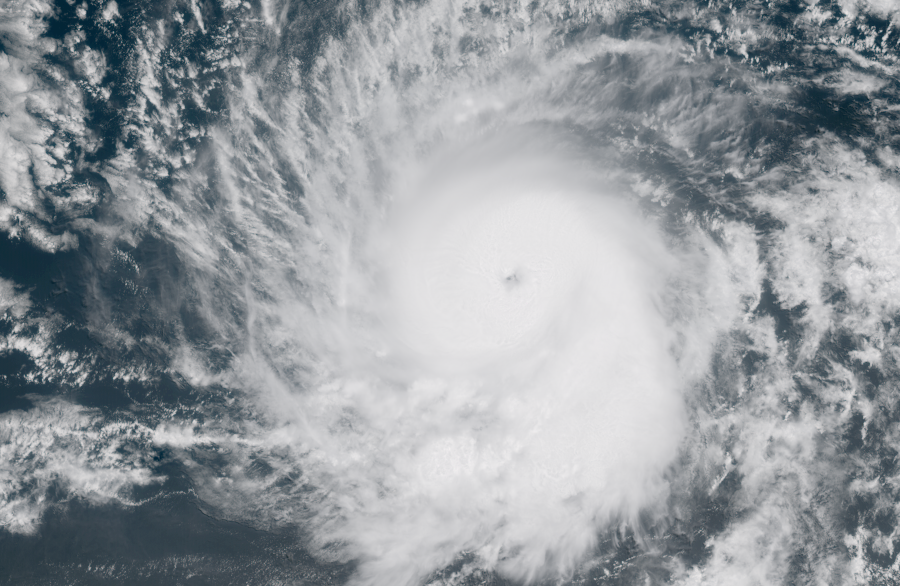
Besides the computer models promoting an El Niño, the weather pattern across the western Pacific seems to be falling in line as well. Massive Super Typhoon Sinlaku — a super typhoon is equivalent to a strong Category 4 or Category 5 hurricane — is pressing in on the islands north of Guam. The U.S. territories of Saipan and the surrounding islands are near the center of the track. Impact time looks to be late tomorrow their time.
Winds on the bottom of Sinlaku's giant circulation are propelling Pacific Ocean water and wave energy from west to east. Bursts of west wind like this support warming in the El Niño region.
With all that in mind, the scientists at Colorado State University released their projection for this hurricane season last week. They're predicting that El Niño will dampen the numbers, at least a bit. They'll update the forecast in early June, when El Niño forecasts normally become more reliable. For now, they're thinking we'll see slightly below normal activity in the Atlantic.
I hasten to add, of course, that nobody in the hurricane zone should take their eye off the ball because of a less-threatening-feeling forecast. The weather pattern could become super-conducive for just the wrong week when a tropical system is positioned to pounce. It's happened in the past, so we have to stay vigilant just in case.
Was 2025 a turning point in hurricane forecasting? It's possible.
While Hurricane Melissa broke meteorological records — it about as strong a hurricane as we’ll ever see in the Atlantic — the brand new Google DeepMind AI model was producing startling forecasts.
Prior to the season, Google allowed us to run the model on past storms so we could see how it performed. It was excellent — enough so that the National Hurricane Center decided to consider the Google forecasts among many other models in real time during the season. The Google model steadily gained credibility, so by the time Melissa developed in October, the NHC had enough confidence in it to explicitly forecast a Cat 5 at landfall, encouraged by a consistent Google forecast.
Disclosure: I had a small role in the design of the presentation of the Google model to the public. But the scientists at Google DeepMind were responsible for the model development.
The NHC ranks the models at the end of every season. In 2025, the Google DeepMind AI model ended up producing the best forecast — both in terms of where the storm was going to track and how strong it was going to be. It was a stunning technological development. Here you see the NHC's graphs.
Notice that the NHC forecast, which the cone and everything else is based on, is the most accurate, with the exception of the Google model. But, of course, they and we didn't know how much weight to put on the forecasts from Google DeepMind through most of the season.
Now that there's a track record, the plan for 2026 is to combine the Google model with other traditional physics-based systems like the GFS and the Euro, plus potentially other AI models, to produce even better forecasts. No model is perfect, and usually model combinations produce the best results.
The Google system works differently from other forecast models. The DeepMind code produces a fan of possible tracks — last year there were 50, this year there will be 1,000 — and then takes the average. The average is the forecast.
Traditional systems produce a single forecast plus a set of other reasonable possibilities, as well. It takes supercomputers a lot of time to produce their 30 or 50 alternate forecasts so we can understand the extent of the uncertainty in the weather pattern. AI systems do much more with a fraction of the horsepower.
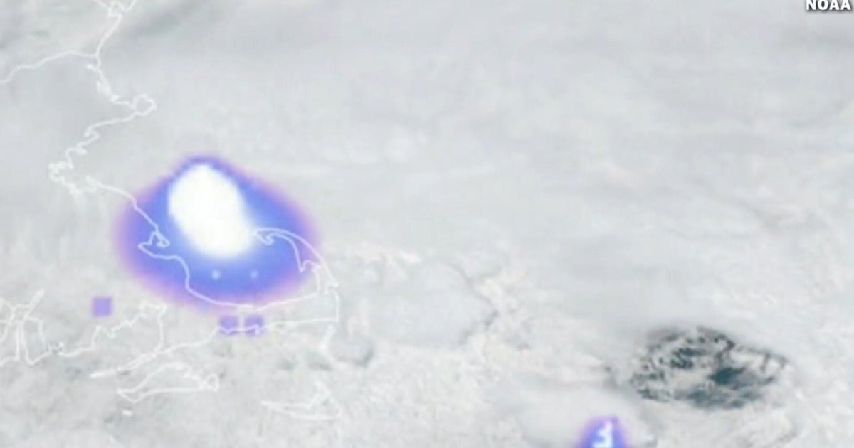
Here's a forecast for Super Typhoon Sinlaku from the Google Weather Lab website. You can see the fan of possible tracks (using 2025 technology) — in theory each line has a 2% chance of being right. The bold line is the average. As of this forecast, Sinlaku was forecast to weaken to a Category 3 equivalent as it approaches the Northern Mariana Islands in the far western Pacific tomorrow.
Most of us experience AI through chatbots — ChatGPT, Claude, Gemini, etc. And anybody who uses them much has likely received extremely confident responses that were completely wrong. But AI deployed in a deep but narrow problem like forecasting hurricanes is focused on the task at hand. It excels at this kind of task where it doesn't need to know about repairing a washing machine or diagnosing a runny nose.
Will AI techniques revolutionize weather forecasting? If I had to bet, I'd say yes. We’ll all see together.
What's Your Reaction?
 Like
0
Like
0
 Dislike
0
Dislike
0
 Love
0
Love
0
 Funny
0
Funny
0
 Angry
0
Angry
0
 Sad
0
Sad
0
 Wow
0
Wow
0